 |
Page XII
Carvoran to Birdoswald
Milecastles 46 to 49
|
 |
 |
|||||||||||||||||||||||||||||||||||||||||||||||||||||||||||||||||||||||||||||||||||||||||||||||||||
 |
||||||||||||||||||||||||||||||||||||||||||||||||||||||||||||||||||||||||||||||||||||||||||||||||||||||
|
||||||||||||||||||||||||||||||||||||||||||||||||||||||||||||||||||||||||||||||||||||||||||||||||||||||
 |
||||||||||||||||||||||||||||||||||||||||||||||||||||||||||||||||||||||||||||||||||||||||||||||||||||||
|
CARVORAN to MC49
From Milecastle 46 north of CARVORAN (MAGNA) Fort where the Roman Army Museum is now situated, the Wall makes its way across the Tipalt Burn just a few yards south of Thirwall Castle which is entirely built from the Wall's stones. and follows on to the village of Gilsland past Milecastle 48 on the west bank of the Poltross Burn and on again to the site of the great bridge across the River Irthing on the other side of which is found the end of this page Milecastle 49. The River Irthing is the western border between the counties of Northumberland and Cumbria Roman Mile = 1620 yards = 0.92Mile = 1.48km |
||||||||||||||||||||||||||||||||||||||||||||||||||||||||||||||||||||||||||||||||||||||||||||||||||||||
 |
|
|||||||||||||||||||||||||||||||||||||||||||||||||||||||||||||||||||||||||||||||||||||||||||||||||||||
 |
 |
 |
||||||||||||||||||||||||||||||||||||||||||||||||||||||||||||||||||||||||||||||||||||||||||||||||||||
|
The site of Carvoran fort is behind the Roman Army Museum Building. and is a large grassed platform with the Vallum visible to its north
|
||||||||||||||||||||||||||||||||||||||||||||||||||||||||||||||||||||||||||||||||||||||||||||||||||||||
|
MAGNA
CARVORAN Shown on the Os Map as MAGNIS Visible as a turf covered platform covering three and a half acres and shown in the Notitia as Magnae the Fort stands to the south of both the Vallum and the Wall, having been erected before them. It was almost certainly built as one of the Stanegate Forts and its original purpose being to guard the junction of the Stanegate and The Maiden Way. The Vallum is seen to deviate to the north as if to avoid the Fort though this deviation is generally explained by the fact that there is the presence of a bog. In Hadrian's time the garrison was the First Cohort of Hamian archers from Syria. This is the only known detatchment of archers in Roman Britain. the Notitia shows the Garrison as the Second Cohort of dalmatians. A number of interesting and significant artifacs have been found here the most important being a roman dry-measure or Modius, made of bronze it bears an inscription in perfect lettering saying that it holds 17.5 sextarii (16.35 pints) and names Emperor Domitian in whose reign it was made with that name crossed out following his condemnation by the Senate. The Measure actually holds twenty pints at it has been suggested that this was a means of cheating the natives who were compelled to deliver a certain tribute of corn.
image:- frank Graham The Roman Wall pg 138. |
||||||||||||||||||||||||||||||||||||||||||||||||||||||||||||||||||||||||||||||||||||||||||||||||||||||
 |
 |
|||||||||||||||||||||||||||||||||||||||||||||||||||||||||||||||||||||||||||||||||||||||||||||||||||||
|
The line of the Wall continues west passing to the north of Carvoran and the site of Milecastle46 is determined by the Causeway over the Fighting Ditch. There is little to see beyond the gateway <<<<<<<<<<< |
 |
|||||||||||||||||||||||||||||||||||||||||||||||||||||||||||||||||||||||||||||||||||||||||||||||||||||
|
<< The site of Milecastle 46
|
||||||||||||||||||||||||||||||||||||||||||||||||||||||||||||||||||||||||||||||||||||||||||||||||||||||
 |
 |
 |
||||||||||||||||||||||||||||||||||||||||||||||||||||||||||||||||||||||||||||||||||||||||||||||||||||
 |
The Wall ran through what is now the hamlet of Holmhead crossing the Tipalt Burn. While the Ditch can be seen on the ridge ahead there is very little mark in the ground of the Wall having been here. At this point the Thirwall Castle can be found above the west bank of the Burn. The Castle is made entirely of Roman Stone and takes it name from the meaning of the word Thirwall "a breach in the Wall" At Holmhead the farmstead bed and breakfast building has Roman inscribed stones in the building fabric. |
|||||||||||||||||||||||||||||||||||||||||||||||||||||||||||||||||||||||||||||||||||||||||||||||||||||
 |
||||||||||||||||||||||||||||||||||||||||||||||||||||||||||||||||||||||||||||||||||||||||||||||||||||||
|
The Wall line crosses the Tipalt Burn at Holmhead This burn is the last major river or burn that flows to the River South Tyne and the east as the Wall approaches the watershed of northern England and any further water courses run to the west. Over a flat field finds the line crossing the Newcastle - Carlisle railway line and the B6318 road there is a small section of wall on the western side of the road. while the Vallum can be seen making its way up the side of the golf course road. |
||||||||||||||||||||||||||||||||||||||||||||||||||||||||||||||||||||||||||||||||||||||||||||||||||||||
 |
 |
 |
||||||||||||||||||||||||||||||||||||||||||||||||||||||||||||||||||||||||||||||||||||||||||||||||||||
 |
 |
|||||||||||||||||||||||||||||||||||||||||||||||||||||||||||||||||||||||||||||||||||||||||||||||||||||
 |
 |
|||||||||||||||||||||||||||||||||||||||||||||||||||||||||||||||||||||||||||||||||||||||||||||||||||||
|
The farm building is on the line of the wall the line of the Wall and the Fighting Ditch can be seen ahead.
|
||||||||||||||||||||||||||||||||||||||||||||||||||||||||||||||||||||||||||||||||||||||||||||||||||||||
 |
||||||||||||||||||||||||||||||||||||||||||||||||||||||||||||||||||||||||||||||||||||||||||||||||||||||
 |
 |
 |
||||||||||||||||||||||||||||||||||||||||||||||||||||||||||||||||||||||||||||||||||||||||||||||||||||
|
<<<<<<<<<<<< The site of Milecastle 47 Chapel House
The site again determined by the causway across the fighting ditch |
||||||||||||||||||||||||||||||||||||||||||||||||||||||||||||||||||||||||||||||||||||||||||||||||||||||
 |
||||||||||||||||||||||||||||||||||||||||||||||||||||||||||||||||||||||||||||||||||||||||||||||||||||||
|
From the Chapel House Milecastle to Green Croft farm a field wall is built on the Wall's foundations
|
||||||||||||||||||||||||||||||||||||||||||||||||||||||||||||||||||||||||||||||||||||||||||||||||||||||
 |
 |
|||||||||||||||||||||||||||||||||||||||||||||||||||||||||||||||||||||||||||||||||||||||||||||||||||||
 |
||||||||||||||||||||||||||||||||||||||||||||||||||||||||||||||||||||||||||||||||||||||||||||||||||||||
 |
||||||||||||||||||||||||||||||||||||||||||||||||||||||||||||||||||||||||||||||||||||||||||||||||||||||
 |
Beyond Green Croft the site of Turret 47a sits at the top of a hill where a stile straddles the field wall. |
|||||||||||||||||||||||||||||||||||||||||||||||||||||||||||||||||||||||||||||||||||||||||||||||||||||
 |
 |
|||||||||||||||||||||||||||||||||||||||||||||||||||||||||||||||||||||||||||||||||||||||||||||||||||||
 |
Dropping down now into the western watershed the Wall line passes through the Hamlet of Gap and the farm buildings on the far side of the access road are built on the line. There is a spectacular view of the Fighting Ditch to the west of Gap. |
|||||||||||||||||||||||||||||||||||||||||||||||||||||||||||||||||||||||||||||||||||||||||||||||||||||
 |
||||||||||||||||||||||||||||||||||||||||||||||||||||||||||||||||||||||||||||||||||||||||||||||||||||||
 |
||||||||||||||||||||||||||||||||||||||||||||||||||||||||||||||||||||||||||||||||||||||||||||||||||||||
 |
 |
|||||||||||||||||||||||||||||||||||||||||||||||||||||||||||||||||||||||||||||||||||||||||||||||||||||
|
On its run down to the Poltross Burn and in the hamlet of Crooks to the south of Gilsland Village the Wall line passes through a small industrial area and some houses before acting as the line of a hedgrow beyond. From here it drops into the Poltross valley. |
 |
|||||||||||||||||||||||||||||||||||||||||||||||||||||||||||||||||||||||||||||||||||||||||||||||||||||
 |
||||||||||||||||||||||||||||||||||||||||||||||||||||||||||||||||||||||||||||||||||||||||||||||||||||||
 |
 |
 |
||||||||||||||||||||||||||||||||||||||||||||||||||||||||||||||||||||||||||||||||||||||||||||||||||||
|
<<<<<<<<< Milecastle 48
The Kings Stables Poltross burn *2 |
 |
|||||||||||||||||||||||||||||||||||||||||||||||||||||||||||||||||||||||||||||||||||||||||||||||||||||
 |
||||||||||||||||||||||||||||||||||||||||||||||||||||||||||||||||||||||||||||||||||||||||||||||||||||||
|
Immediately beyond the Milecastle the line is cut again by the embankment for the Newcastle - Carlisle railway track.
On the far side of the embankment the Wall again emerges and runs for a good 400 yards past what was the Roman Way guest house (now, seemingly a victim of fire and neglect) mentioned by Hunter Davies and David Harrison when compiling their respective books. |
||||||||||||||||||||||||||||||||||||||||||||||||||||||||||||||||||||||||||||||||||||||||||||||||||||||
 |
 |
|||||||||||||||||||||||||||||||||||||||||||||||||||||||||||||||||||||||||||||||||||||||||||||||||||||
 |
||||||||||||||||||||||||||||||||||||||||||||||||||||||||||||||||||||||||||||||||||||||||||||||||||||||
 |
 |
 |
||||||||||||||||||||||||||||||||||||||||||||||||||||||||||||||||||||||||||||||||||||||||||||||||||||
 |
 |
 |
||||||||||||||||||||||||||||||||||||||||||||||||||||||||||||||||||||||||||||||||||||||||||||||||||||
|
Across the road an excellent length of the Wall makes its way to the Willowford Bridge over the River Irthing.
|
||||||||||||||||||||||||||||||||||||||||||||||||||||||||||||||||||||||||||||||||||||||||||||||||||||||
 |
 |
|||||||||||||||||||||||||||||||||||||||||||||||||||||||||||||||||||||||||||||||||||||||||||||||||||||
 |
||||||||||||||||||||||||||||||||||||||||||||||||||||||||||||||||||||||||||||||||||||||||||||||||||||||
 |
||||||||||||||||||||||||||||||||||||||||||||||||||||||||||||||||||||||||||||||||||||||||||||||||||||||
 |
 |
 |
||||||||||||||||||||||||||||||||||||||||||||||||||||||||||||||||||||||||||||||||||||||||||||||||||||
|
The Narrow Wall can be seen to be sitting on the Broad Wall foundations
|
||||||||||||||||||||||||||||||||||||||||||||||||||||||||||||||||||||||||||||||||||||||||||||||||||||||
 |
 |
|||||||||||||||||||||||||||||||||||||||||||||||||||||||||||||||||||||||||||||||||||||||||||||||||||||
 |
||||||||||||||||||||||||||||||||||||||||||||||||||||||||||||||||||||||||||||||||||||||||||||||||||||||
 |
Set into the wall of a building at Willowford Farm is a Roman inscibed stone. CHO V C G PILIPPI From the fifth cohort the century of GELLIVS PHILIPPUS (built This) |
|||||||||||||||||||||||||||||||||||||||||||||||||||||||||||||||||||||||||||||||||||||||||||||||||||||
 |
 |
|||||||||||||||||||||||||||||||||||||||||||||||||||||||||||||||||||||||||||||||||||||||||||||||||||||
|
Turret 48b remains are found at Willowford Farm just as the wall runs downhill to the Roman Bridge Abutment
|
||||||||||||||||||||||||||||||||||||||||||||||||||||||||||||||||||||||||||||||||||||||||||||||||||||||
 |
 |
|||||||||||||||||||||||||||||||||||||||||||||||||||||||||||||||||||||||||||||||||||||||||||||||||||||
 |
||||||||||||||||||||||||||||||||||||||||||||||||||||||||||||||||||||||||||||||||||||||||||||||||||||||
|
In the picture to the left I have indicated with the yellow arrow where the continuation of the stone wall is to found along with the site of Milecastle 49 |
||||||||||||||||||||||||||||||||||||||||||||||||||||||||||||||||||||||||||||||||||||||||||||||||||||||
 |
||||||||||||||||||||||||||||||||||||||||||||||||||||||||||||||||||||||||||||||||||||||||||||||||||||||
 |
The River Irthing has moved its course some distance west since the Romans built their bridge. The western abutment is lost and the Stone Wall can be seen in continuation on top of the steep bank of what is there today. |
|||||||||||||||||||||||||||||||||||||||||||||||||||||||||||||||||||||||||||||||||||||||||||||||||||||
|
West of the Willowford Bridgehead the Wall deviates from the expected rules, and for its deviations there are still no persuasive arguments. Logic ends at the River Irthing bridgehead. *1 Having used the terrain to military advantage for the miles west from Pons Aelius and a stone wall. For the last 30 miles they planned a wall of turf with a wooden parapet. The common factor is clearly that along this sector the planners no longer thought in terms of a serious threat from the north. The wall as built was a military mess, it is inconcevable that it was set up to face the same dangers as the central and eastern sectors *1 |
||||||||||||||||||||||||||||||||||||||||||||||||||||||||||||||||||||||||||||||||||||||||||||||||||||||
 |
 |
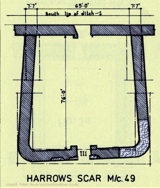
<<<<<<<<< Milecastle.49
Harrows Scar *2 |
 |
|||||||||||||||||||||||||||||||||||||||||||||||||||||||||||||||||||||||||||||||||||||||||||||||||||
 |
||||||||||||||||||||||||||||||||||||||||||||||||||||||||||||||||||||||||||||||||||||||||||||||||||||||
 |
||||||||||||||||||||||||||||||||||||||||||||||||||||||||||||||||||||||||||||||||||||||||||||||||||||||
 |
 |
|||||||||||||||||||||||||||||||||||||||||||||||||||||||||||||||||||||||||||||||||||||||||||||||||||||
|
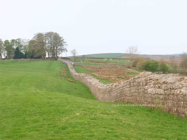
The Wall from the Milecastle to Birdoswald Fort is a fine section standing ten courses high. My literature advises centurial stones masons marks etc.are to be found on eight stones along its length but I'm afraid they eluded me! |
||||||||||||||||||||||||||||||||||||||||||||||||||||||||||||||||||||||||||||||||||||||||||||||||||||||
 |
Birdoswald
BANNA Built in the Cavalry Fort configuration with the Turf wall as its Wall line |
|||||||||||||||||||||||||||||||||||||||||||||||||||||||||||||||||||||||||||||||||||||||||||||||||||||
 |
 |
|||||||||||||||||||||||||||||||||||||||||||||||||||||||||||||||||||||||||||||||||||||||||||||||||||||
 |
||||||||||||||||||||||||||||||||||||||||||||||||||||||||||||||||||||||||||||||||||||||||||||||||||||||
 |
||||||||||||||||||||||||||||||||||||||||||||||||||||||||||||||||||||||||||||||||||||||||||||||||||||||
 |
||||||||||||||||||||||||||||||||||||||||||||||||||||||||||||||||||||||||||||||||||||||||||||||||||||||
|
References for Page 12 *1 David Devine -The Northwest Frontier of Rome 1969 p129 *2 Milecastle Profiles Raymond Hunnysett - 1980 Archeaologia fifth ser VolVIII 6 *3 Plan of Birdoswald Fort - Frank Graham The Roman Wall 1979 Pg 146 Map of Magna - Maclaughlan 1857 |
||||||||||||||||||||||||||||||||||||||||||||||||||||||||||||||||||||||||||||||||||||||||||||||||||||||
 |
Milecastles
This first plan provided for a wall 10ft wide, 15ft 6 inches high and surmounted by a 6ft crenellation. to the north of this was a 20 ft berm, a standard fighting ditch 30ft by 13ft 6 inches, and a glacis composed of the spoil of the ditch, approximately 60ft in width. At each Roman mile was a milecastle with a north gate opening through the Wall, surmounted by a defensive turret and a south gate. In the original plan there were two barracks and the milecastle maintained a turret on either hand for the patrol garrison. South of the wall was the Vallum, a complex consisting of a 20 ft ditch with a wide bottom section and mounds composed of spoil to north and south. The wall was built to the design width only on the eastern slope. The Milecastles built before the change of plan had 10ft wings on either side. The curtain wall as finally built was substantially narrower and the join is indicated in the diagram. This information and the diagram taken from Richard Devine The Northwest Frontier of the Roman Empire Chap2 pg 27' |
|||||||||||||||||||||||||||||||||||||||||||||||||||||||||||||||||||||||||||||||||||||||||||||||||||||
 |
||||||||||||||||||||||||||||||||||||||||||||||||||||||||||||||||||||||||||||||||||||||||||||||||||||||
 |
||||||||||||||||||||||||||||||||||||||||||||||||||||||||||||||||||||||||||||||||||||||||||||||||||||||
