|
 |
|
Page XIV
Hare Hill to Newton
Milecastles 53 to 58
|
 |
 |
|
|
 |
|
 |
|
MC 53 to MC58
The purpose of this website is to show what presently exists on the line of Hadrian's Wall. After the tall remnant encounterd immediately on leaving MC53 there are now little in the way of Roman stones to be found in situ as we travel west other than the core and some foundations.
Unlike further to the east where we had the good offices of John Clayton and the Antiquarian zeal of William Hutton there would seem to have been no local benefactor.
South of this short stretch from Hare Hill to Newton I have added information about The Fart at CAMBOGLANNA near MC 57
Entirely in modern Cumbria. From the hight of Hare Hill the line runs westward along and down a ridge to cross the Burtholme Beck before climbing again near Dovecote and onto Walton Village. Now South Westerly it rises and falls to reach Newton.
Roman Mile = 1620 yards = 0.92Mile = 1.48km

Start point for this page
|
|
 |
|
|
Location
|
Milecastle
|
|
Segedunum to Pons Aelis
|
|
|
Pons Aelis to Condercum
|
|
|
Condercum to Heddon
|
|
|
Heddon to Harlow Hill
|
|
|
Harlow Hill to Portgate
|
|
|
Portgate to Chesters
|
|
|
Chesters to Brocolitia
|
|
|
Brocolitia to Vercovicivm
|
|
|
Vercovicivm to MC40
|
|
|
MC40 to Aesica
|
|
|
Aesica to Carvoran
|
|
|
Carvoran to Birdoswald
|
|
|
Birdoswald to Hare Hill
|
|
|
Hare Hill to Newton
|
|
|
Newton to Stanwix
|
|
|
Stanwix to Dykesfield
|
|
|
Dykesfield to Maia
|
|
|
|
|
|
|
|
|
|
|
|
|
|
|
|
|
Milecastle 53 :- Its gates were Type III and its internal dimentions 76.5 ft from north to south and 72 ft from east to west. in 1932 a fragment of the levelled Turf wall was found inside it. (NY5648 6460)
|
|
|
|
|
|
|
|
 |
|
 |
|
|
 |
|
|
^^^The site of Milecastle 53
|
|
|
|
|
|
|
|
|
|
|
 |
|
|
|
|
 |
|
 |
|
 |
|
from Milecastle 53 the steep climb passes the tallest remains on the Wall. On to the top of the Hare Hill the farm of that name is built on the line of theWall.
|
|
|
|
|
|
|
 |
|
 |
|
|
 |
|
 |
|
 |
|
 |
|
|
Down the western slope of Hare Hill to Hayton gate
|
|
|
|
|
|
|
 |
 |
|
|
|
|
|
|
|
|
<<<<<<<The site of Milecastle .54
|
|
|
Milecastle 54 was excavated in 1934.It measured internally 19.3 metres east to west by 23.3 metres north to south. It contained a west barrack comprising two rooms, one of which had stone benches, a hearth and a millstone. It overlay an earlier Turf Wall milecastle
|
|
|
|
|
|
|
 |
|
 |
|
|
 |
|
 |
|
|
|
|
 |
|
|
 |
|
|
Site of Turret 54a ^^^
|
|
|
|
|
|
 |
 |
|
 |
 |
|
|
|
|
|
|
|
|
|
|
|
 |
 |
|
 |
 |
|
 |
 |
|
 |
|
|
 |
|
<<<<<<<The site of Milecastle .55
Low Wall
|
|
|
|
|
Milecastle 55 was discovered and partly excavated in 1900. It measured 22m East To West
the North to South length was unclear
|
|
|
|
|
|
|
|
 |
 |
 |
|
 |
 |
|
 |
 |
 |
|
|
|
From MC 55 to Dovecote Bridge
|
|
|
|
|
|
 |
<<<<<<<<The remains of the Wall on the western side of the King Water at Dovecote Bridge was uncovered for 20 years but being Cumbrian red sandstone it was suffering from erosion so they were re-interred in 1983
|
|
|
|
|
 |
|
|
|
|
 |
|
|
 |
|
 |
|
**
The remains of the Wall pass under the village of Walton and the considered site for Milecastle 56 is OS reference NY522 643
The yard opposite what was the Centurion Inn conforms to that location
The building just east of the yard is called Roman cottage
|
|
 |
|
|
|
|
|
|
|
<<<<<<<The site of Milecastle 56
Walton
|
|
|
|
|
|
|
|
|
|
|
 |
 |
|
 |
|
 |
 |
|
|
 |
|
 |
 |
|
<<<<<<<<The line of the Wall runs up through the wood and skirts the Farm buildings at Sandysikes Farm.
There is a stretch of the wall in the grounds much overgrown it appears again as a wide grassy ridge running down to the River Cambeck and crosses the river at the site of a circular wier.
|
|
|
|
|
|
 |
|
 |
|
 |
|
 |
|
|
|
|
 |
|
 |
|
 |
|
 |
|
|
<<<<<<<The site of Milecastle 57
Cambeckhill
NY 5801 6368
|
|
|
|
|
|
|
|
|
Castlesteads
CAMBOGLANNA
The Name of the Fort
A number of names have been attributed to the Roman Fort at Castlesteads. The Rudge Cup and Amiens skillet give the Roman name as UXELLODUNUM. on MacLachlan's map shown here he has named it PETRIANA. Now AMBOGLANNA or CAMBOGLANNA as shown on OS maps.
Following on from the renaming of Birdoswald as Banna the solution having been found by Hassall (1976, 113) in his discussion of the British section of the Notitia, where it is proposed that there is a lacuna in an earlier version of the document and with restoration of the text Camboglanna should thus be located at Castlesteads on the Cambeck, where cohors II Tungrorum is attested epigraphically (RIB 1981-3). This argument is decribed by Rivet and Smith (1979, 262) as "not only acceptable, but, once demonstrated, obvious", and the identification has achieved general acceptance. (eg. Mann 1989, 75) The topographical relevance to Birdoswald of the name Banna, with its meaning of a spur or a promontory is very clear. *1
In 1934 the fort was partly excavated: The east, south and west walls were uncovered, the two side double gates and the south-west angle tower, surrounded by a single ditch. the north wall had collapsed into the valley.*2
Camboglanna lies within the Vallum but not adjacent to the Wall, the only one in such a position The Wall had already been built at the most convenient point for crossing the Cambeck and then later the Fort was built on the strongest spot. The Wall to the north of the fort was demolished in 1791 when Castlesteads House was built. .*3
The Fort lies some 500 m SE of Cambeckhill Farm the site of Milecastle 57
|
 |
|
|
|
|
|
|
|
|
|
|
|
 |
 |
 |
|
 |
 |
 |
|
|
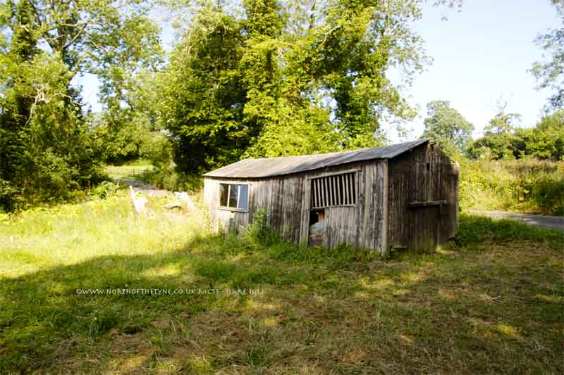
The Wall line from Cambeckhill MC 57 follows through the yard of the Beck Farm and up a steep slope to Heads Wood.
|
|
|
|
|
|
 |
 |
|
 |
 |
|
|
The Wall line runs through Newton Farm is crossed by the Brampton - Longtown road A6071 and runs behind the builings on the Newton - Walby road to Milecastle MC 58
|
|
|
|
|
|
|
|
|
 |
|
 |
 |
|
 |
|
 |
|
|
<<<<<<<The site of Milecastle 58
Newton
NY 4978 6258
|
|
|
|
|
|
|
|
References for Page 14
*1 Madeleine Hope Dodds - A History of Northumberland Vol XIII pg 521
*2 Frank Graham - The Roman Wall a comprehensive history and Guide Pg 169
*3 Frank Graham - The Roman Wall a comprehensive history and Guide Pg 171
Map of Petriana ( Camboglanna) - Maclaughlan 1857
|
|
 |
Milecastles
This first plan provided for a wall 10ft wide, 15ft 6 inches high and surmounted by a 6ft crenellation. to the north of this was a 20 ft berm, a standard fighting ditch 30ft by 13ft 6 inches, and a glacis composed of the spoil of the ditch, approximately 60ft in width.
At each Roman mile was a milecastle with a north gate opening through the Wall, surmounted by a defensive turret and a south gate. In the original plan there were two barracks and the milecastle maintained a turret on either hand for the patrol garrison.
South of the wall was the Vallum, a complex consisting of a 20 ft ditch with a wide bottom section and mounds composed of spoil to north and south. The wall was built to the design width only on the eastern slope. The Milecastles built before the change of plan had 10ft wings on either side. The curtain wall as finally built was substantially narrower and the join is indicated in the diagram.
This information and the diagram taken from Richard Devine The Northwest Frontier of the Roman Empire Chap2 pg 27
|
|
|
|
|
|
|
|
|
|
|
|
|
|
|
 |
|
|
 |
|
 |
|
|
|
|
|
|
|
|
|
|
|
|
|
|
|
|
|
|
|
|
|
|
|
|
|
|
|
|
|
|
|
|
|
|
|
|
|
|
|
|
|
|
|
|
|
|
|
|
|
|
|